##ciekawa_strona##
Compare Pakistan (2002) - Nepal (2002)
Compare Pakistan (2002) z Nepal (2002)
| Pakistan (2002) | Nepal (2002) | |
 |  | |
| Administrative divisions | 4 provinces, 1 territory*, and 1 capital territory**; Balochistan, Federally Administered Tribal Areas*, Islamabad Capital Territory**, North-West Frontier Province, Punjab, Sindh
note: the Pakistani-administered portion of the disputed Jammu and Kashmir region includes Azad Kashmir and the Northern Areas |
14 zones (anchal, singular and plural); Bagmati, Bheri, Dhawalagiri, Gandaki, Janakpur, Karnali, Kosi, Lumbini, Mahakali, Mechi, Narayani, Rapti, Sagarmatha, Seti |
| Age structure | 0-14 years: 39.9% (male 30,321,217; female 28,581,334)
15-64 years: 56% (male 42,254,996; female 40,392,092) 65 years and over: 4.1% (male 2,984,391; female 3,129,399) (2002 est.) |
0-14 years: 40% (male 5,346,422; female 5,007,416)
15-64 years: 56.4% (male 7,476,202; female 7,125,471) 65 years and over: 3.6% (male 453,263; female 465,143) (2002 est.) |
| Agriculture - products | cotton, wheat, rice, sugarcane, fruits, vegetables; milk, beef, mutton, eggs | rice, corn, wheat, sugarcane, root crops; milk, water buffalo meat |
| Airports | 120 (2001) | 45 (2001) |
| Airports - with paved runways | total: 87
over 3,047 m: 14 2,438 to 3,047 m: 21 1,524 to 2,437 m: 32 914 to 1,523 m: 17 under 914 m: 3 (2002) |
total: 9
over 3,047 m: 1 1,524 to 2,437 m: 1 914 to 1,523 m: 7 (2002) |
| Airports - with unpaved runways | total: 38
1,524 to 2,437 m: 9 914 to 1,523 m: 9 under 914 m: 19 (2002) |
total: 36
1,524 to 2,437 m: 1 914 to 1,523 m: 7 under 914 m: 28 (2002) |
| Area | total: 803,940 sq km
land: 778,720 sq km water: 25,220 sq km |
total: 140,800 sq km
land: 136,800 sq km water: 4,000 sq km |
| Area - comparative | slightly less than twice the size of California | slightly larger than Arkansas |
| Background | The separation in 1947 of British India into the Muslim state of Pakistan (with two sections West and East) and largely Hindu India was never satisfactorily resolved. A third war between these countries in 1971 resulted in East Pakistan seceding and becoming the separate nation of Bangladesh. A dispute over the state of Kashmir is ongoing. In response to Indian nuclear weapons testing, Pakistan conducted its own tests in 1998. | In 1951, the Nepalese monarch ended the century-old system of rule by hereditary premiers and instituted a cabinet system of government. Reforms in 1990 established a multiparty democracy within the framework of a constitutional monarchy. A maoist insugency, launched in 1996, has gained traction and is threatening to bring down the regime. Ten members of the royal family, including the king and queen, were massacred in a family dispute in 2001. In October 2002, the new king dismissed the prime minister and his cabinet for "incompetence" after they dissolved the parliament and were subsequently unable to hold elections because of the ongoing insurgency. The country is now governed by the king and his appointed cabinet until elections can be held at some unspecified future date. |
| Birth rate | 30.4 births/1,000 population (2002 est.) | 32.94 births/1,000 population (2002 est.) |
| Budget | revenues: $8.9 billion
expenditures: $11.6 billion, including capital expenditures of $NA (FY00/01 est.) |
revenues: $665 million
expenditures: $1.1 billion, including capital expenditures of $NA (FY99/00 est.) |
| Capital | Islamabad | Kathmandu |
| Climate | mostly hot, dry desert; temperate in northwest; arctic in north | varies from cool summers and severe winters in north to subtropical summers and mild winters in south |
| Coastline | 1,046 km | 0 km (landlocked) |
| Constitution | 10 April 1973, suspended 5 July 1977, restored with amendments 30 December 1985; suspended 15 October 1999 | 9 November 1990 |
| Country name | conventional long form: Islamic Republic of Pakistan
conventional short form: Pakistan former: West Pakistan |
conventional long form: Kingdom of Nepal
conventional short form: Nepal |
| Currency | Pakistani rupee (PKR) | Nepalese rupee (NPR) |
| Death rate | 9.02 deaths/1,000 population (2002 est.) | 10.03 deaths/1,000 population (2002 est.) |
| Debt - external | $31.5 billion (2001 est.) | $2.55 billion (FY00/01) |
| Diplomatic representation from the US | chief of mission: Ambassador Nancy J. POWELL
embassy: Diplomatic Enclave, Ramna 5, Islamabad mailing address: P. O. Box 1048, Unit 62200, APO AE 09812-2200 telephone: [92] (51) 2080-0000 FAX: [92] (51) 2276427 consulate(s): Karachi, Lahore, Peshawar |
chief of mission: Ambassador Michael E. MALINOWSKI
embassy: Panipokhari, Kathmandu mailing address: use embassy street address telephone: [977] (1) 411179 FAX: [977] (1) 419963 |
| Diplomatic representation in the US | chief of mission: Ambassador Ashraf Jehangir QAZI
chancery: 2315 Massachusetts Avenue NW, Washington, DC 20008 telephone: [1] (202) 939-6205 FAX: [1] (202) 387-0484 consulate(s) general: Los Angeles, New York, and Sunnyvale (California) |
chief of mission: Ambassador-designate Jai Pratap RANA
chancery: 2131 Leroy Place NW, Washington, DC 20008 telephone: [1] (202) 667-4550 FAX: [1] (202) 667-5534 consulate(s) general: New York |
| Disputes - international | armed stand-off with India over the status and sovereignty of Kashmir continues; dispute with India over the terminus of Rann of Kutch prevents extension of a maritime boundary; water-sharing problems with India persist over the Indus River (Wular Barrage); close ties with Pashtuns in Afghanistan make long border difficult to control | formed Joint Border committee with India in 2001 to resolve 53 disputed sections of boundary covering an area of 720 sq km; approximately 100,000 Bhutanese refugees living in Nepal, 90% of whom reside in seven UN Office of the High Commissioner for Refugees camps, place decades-long strains on Nepal |
| Economic aid - recipient | $2 billion (FY99/00) | $424 million (FY00/01) |
| Economy - overview | Pakistan, an impoverished and underdeveloped country, suffers from internal political disputes, lack of foreign investment, and a costly confrontation with neighboring India. Pakistan's economic prospects, marred by poor human development indicators, low levels of foreign investment, and reliance on international creditors for hard currency inflows, were nonetheless on an upswing through most of 2001. The MUSHARRAF government made significant inroads in macroeconomic reform - it completed an IMF short-term loan program for the first time and improved its standing with international creditors by increasing revenue collection and restraining the fiscal deficit in the 2001/02 budget. While Pakistan has capitalized on its international standing after the 11 September terrorist attacks on the US by garnering substantial assistance from abroad - including $1.3 billion in IMF Poverty Reduction and Growth Facility aid and $12.5 billion in Paris Club debt rescheduling - long-term prospects remain uncertain. GDP growth will continue to hinge on crop performance; dependence on foreign oil leaves the import bill vulnerable to fluctuating oil prices; and foreign and domestic investors remain wary of committing to projects in Pakistan. Pakistani trade levels - already in decline due to the global economic downturn - worsened in the aftermath of the September 11 attacks. | Nepal is among the poorest and least developed countries in the world with nearly half of its population living below the poverty line. Agriculture is the mainstay of the economy, providing a livelihood for over 80% of the population and accounting for 41% of GDP. Industrial activity mainly involves the processing of agricultural produce including jute, sugarcane, tobacco, and grain. Textile and carpet production, accounteing for about 80% of foreign exchange earnings in recent years, contracted significantly in 2001 due to the overall slowdown in the world economy and pressures by Maoist insurgents on factory owners and workers. Security concerns in the wake of Maoist activity, the June massacre of many members of the royal family, and the September 11 terrorist attacks in the US led to a decrease in tourism, another key source of foreign exchange. Agricultural production is growing by about 5% on average as compared with annual population growth of 2.3%. Since May 1991, the government has been moving forward with economic reforms, particularly those that encourage trade and foreign investment, e.g., by reducing business licenses and registration requirements to simplify investment procedures. The government has also been cutting expenditures by reducing subsidies, privatizing state industries, and laying off civil servants. More recently, however, political instability - five different governments over the past few years - has hampered Kathmandu's ability to forge consensus to implement key economic reforms. Nepal has considerable scope for accelerating economic growth by exploiting its potential in hydropower and tourism, areas of recent foreign investment interest. Prospects for foreign trade or investment in other sectors will remain poor, however, because of the small size of the economy, its technological backwardness, its remoteness, its landlocked geographic location, and its susceptibility to natural disaster. The international community's role of funding more than 60% of Nepal's development budget and more than 28% of total budgetary expenditures will likely continue as a major ingredient of growth. |
| Electricity - consumption | 58.299 billion kWh (2000) | 1.431 billion kWh (2000) |
| Electricity - exports | 0 kWh (2000) | 95 million kWh (2000) |
| Electricity - imports | 0 kWh (2000) | 174 million kWh (2000) |
| Electricity - production | 62.687 billion kWh (2000) | 1.454 billion kWh (2000) |
| Electricity - production by source | fossil fuel: 64%
hydro: 35% nuclear: 1% other: 0% (2000) |
fossil fuel: 10%
hydro: 90% nuclear: 0% other: 0% (2000) |
| Elevation extremes | lowest point: Indian Ocean 0 m
highest point: K2 (Mt. Godwin-Austen) 8,611 m |
lowest point: Kanchan Kalan 70 m
highest point: Mount Everest 8,850 m (1999 est.) |
| Environment - current issues | water pollution from raw sewage, industrial wastes, and agricultural runoff; limited natural fresh water resources; a majority of the population does not have access to potable water; deforestation; soil erosion; desertification | deforestation (overuse of wood for fuel and lack of alternatives); contaminated water (with human and animal wastes, agricultural runoff, and industrial effluents); wildlife conservation; vehicular emissions |
| Environment - international agreements | party to: Biodiversity, Climate Change, Desertification, Endangered Species, Environmental Modification, Hazardous Wastes, Law of the Sea, Marine Dumping, Ozone Layer Protection, Ship Pollution, Wetlands
signed, but not ratified: Marine Life Conservation, Nuclear Test Ban |
party to: Biodiversity, Climate Change, Desertification, Endangered Species, Hazardous Wastes, Law of the Sea, Nuclear Test Ban, Ozone Layer Protection, Tropical Timber 83, Tropical Timber 94, Wetlands
signed, but not ratified: Marine Dumping, Marine Life Conservation |
| Ethnic groups | Punjabi, Sindhi, Pashtun (Pathan), Baloch, Muhajir (immigrants from India at the time of partition and their descendants) | Brahman, Chetri, Newar, Gurung, Magar, Tamang, Rai, Limbu, Sherpa, Tharu, and others (1995) |
| Exchange rates | Pakistani rupees per US dollar - 60.719 (January 2002), 61.927 (2001), 53.648 (2000), 49.118 (1999), 44.943 (1998), 40.918 (1997) | Nepalese rupees per US dollar - 76.675 (January 2002), 74.961 (2001), 71.094 (2000), 68.239 (1999), 65.976 (1998), 58.010 (1997) |
| Executive branch | note: following a military takeover on 12 October 1999, Chief of Army Staff and Chairman of the Joint Chiefs of Staff Committee, General Pervez MUSHARRAF, suspended Pakistan's constitution and assumed the additional title of Chief Executive; exercising the powers of the head of the government, he appointed an eight-member National Security Council to function as Pakistan's supreme governing body; on 12 May 2000, Pakistan's Supreme Court unanimously validated the October 1999 coup and granted MUSHARRAF executive and legislative authority for three years from the coup date; on 20 June 2001, MUSHARRAF named himself as president and was sworn in, replacing Mohammad Rafiq TARAR; in a referendum held on 30 April 2002, MUSHARRAF's presidency was extended by five more years
chief of state: President Pervez MUSHARRAF (since 20 June 2001) note - MUSHARRAF is both chief of state and head of government head of government: Chief Executive Pervez MUSHARRAF (since 12 May 2000) note - MUSHARRAF is both chief of state and head of government cabinet: Cabinet appointed by the chief executive elections: legislative election last held 10 October 2002 (next to be held NA 2007); prior to the military takeover, Pakistan had an elected president and prime minister; the president was elected by Parliament for a five-year term; election last held 31 December 1997; following legislative elections, the leader of the majority party or majority coalition was usually elected prime minister by the National Assembly election results: results are for the 10 October 2002 election for prime minister - Mir Zafarullah Khan JAMALI elected prime minister (not a position of real power) |
chief of state: King GYANENDRA Bir Bikram Shah (succeeded to the throne 4 June 2001 following the death of his nephew, King DIPENDRA Bir Bikram Shah)
head of government: Prime Minister Lokendra Bahadur CHAND (since 11 October 2002) cabinet: Cabinet appointed by the monarch on the recommendation of the prime minister elections: none; the monarch is hereditary; following legislative elections, the leader of the majority party or leader of a majority coalition is usually appointed prime minister by the monarch note: King BIRENDRA Bir Bikram Shah Dev died in a bloody shooting at the royal palace on 1 June 2001 that also claimed the lives of most of the royal family; King BIRENDRA's son, Crown Price DIPENDRA, is believed to have been responsible for the shootings before fatally wounding himself; immediately following the shootings and while still clinging to life, DIPENDRA was crowned king; he died three days later and was succeeded by his uncle |
| Exports | $8.8 billion f.o.b. (2001) | $757 million f.o.b., but does not include unrecorded border trade with India (FY00/01 est.) |
| Exports - commodities | textiles (garments, cotton cloth, and yarn), rice, other agricultural products | carpets, clothing, leather goods, jute goods, grain |
| Exports - partners | US 24.8%, UK 6.5%, UAE 6.2%, Hong Kong 5.9%, Germany 5.6%, (2000) | India 48%, US 26%, Germany 11% (FY00/01) |
| Fiscal year | 1 July - 30 June | 16 July - 15 July |
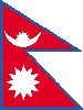
| Flag description | green with a vertical white band (symbolizing the role of religious minorities) on the hoist side; a large white crescent and star are centered in the green field; the crescent, star, and color green are traditional symbols of Islam | red with a blue border around the unique shape of two overlapping right triangles; the smaller, upper triangle bears a white stylized moon and the larger, lower triangle bears a white 12-pointed sun |
| GDP | purchasing power parity - $299 billion (2001 est.) | purchasing power parity - $35.6 billion (2001 est.) |
| GDP - composition by sector | agriculture: 26%
industry: 24% services: 50% (2001 est.) |
agriculture: 41%
industry: 22% services: 37% (2000 est.) |
| GDP - per capita | purchasing power parity - $2,100 (2001 est.) | purchasing power parity - $1,400 (2001 est.) |
| GDP - real growth rate | 3.3% (2001 est.) | 2.6% (2001 est.) |
| Geographic coordinates | 30 00 N, 70 00 E | 28 00 N, 84 00 E |
| Geography - note | controls Khyber Pass and Bolan Pass, traditional invasion routes between Central Asia and the Indian Subcontinent | landlocked; strategic location between China and India; contains eight of world's 10 highest peaks, including Mount Everest - the world's tallest - on the border with China |
| Heliports | 13 (2002) | - |
| Highways | total: 247,811 km
paved: 141,252 km (including 339 km of expressways) unpaved: 106,559 km (1998) |
total: 13,223 km
paved: 4,073 km unpaved: 9,150 km (April 1999) |
| Household income or consumption by percentage share | lowest 10%: 4%
highest 10%: 28% (1997) (1997) |
lowest 10%: 3%
highest 10%: 30% (1995-96) |
| Illicit drugs | opium poppy cultivation practically eliminated; key transit point for Southwest Asian heroin bound for Western markets; Afghan narcotics continue to transit Federally Administered Tribal Areas, Balochistan Province, and Karachi; financial crimes related to drug trafficking, terrorism, corruption, and smuggling remain problems | illicit producer of cannabis for the domestic and international drug markets; transit point for opiates from Southeast Asia to the West |
| Imports | $9.2 billion f.o.b. (2001) | $1.6 billion f.o.b. (FY00/01 est.) |
| Imports - commodities | machinery, petroleum, petroleum products, chemicals, transportation equipment, edible oils, grains, pulses, flour | gold, machinery and equipment, petroleum products, fertilizer |
| Imports - partners | Kuwait 11.7%, UAE 10.7%, Saudi Arabia 10.5%, US 6%, Japan 5.6% (2000) | India 39%, Singapore 10%, China/Hong Kong 9%, (FY00/01) |
| Independence | 14 August 1947 (from UK) | 1768 (unified by Prithvi Narayan Shah) |
| Industrial production growth rate | 7% (2001 est.) | 8.7% (FY99/00) |
| Industries | textiles, food processing, beverages, construction materials, clothing, paper products, shrimp | tourism, carpet, textile; small rice, jute, sugar, and oilseed mills; cigarette; cement and brick production |
| Infant mortality rate | 78.52 deaths/1,000 live births (2002 est.) | 72.36 deaths/1,000 live births (2002 est.) |
| Inflation rate (consumer prices) | 4% (2001 est.) | 2.1% |
| International organization participation | AsDB, ASEAN (dialogue partner), C (suspended), CCC, CP, ECO, ESCAP, FAO, G-19, G-24, G-77, IAEA, IBRD, ICAO, ICC, ICFTU, ICRM, IDA, IDB, IFAD, IFC, IFRCS, IHO, ILO, IMF, IMO, Interpol, IOC, IOM, ISO, ITU, MINURSO, MONUC, NAM, OAS (observer), OIC, OPCW, PCA, SAARC, UN, UNAMSIL, UNCTAD, UNESCO, UNHCR, UNIDO, UNIKOM, UNMIBH, UNMIK, UNMOP, UNOMIG, UNTAET, UPU, WCL, WFTU, WHO, WIPO, WMO, WToO, WTrO | AsDB, CCC, CP, ESCAP, FAO, G-77, IBRD, ICAO, ICC, ICFTU, ICRM, IDA, IFAD, IFC, IFRCS, ILO, IMF, IMO, Interpol, IOC, IOM (observer), ISO (correspondent), ITU, MONUC, NAM, OPCW, SAARC, UN, UNAMSIL, UNCTAD, UNESCO, UNFICYP, UNIDO, UNIFIL, UNMEE, UNMIBH, UNMIK, UNMOP, UNMOT, UNTAET, UPU, WFTU, WHO, WIPO, WMO, WToO, WTrO (observer) |
| Internet Service Providers (ISPs) | 30 (2000) | 6 (2000) |
| Irrigated land | 180,000 sq km (1998 est.) | 11,350 sq km (1998 est.) |
| Judicial branch | Supreme Court (justices appointed by the president); Federal Islamic or Shari'a Court | Supreme Court or Sarbochha Adalat (chief justice is appointed by the monarch on recommendation of the Constitutional Council; the other judges are appointed by the monarch on the recommendation of the Judicial Council) |
| Labor force | 40.4 million
note: extensive export of labor, mostly to the Middle East, and use of child labor (2000) |
10 million
note: severe lack of skilled labor (1996 est.) |
| Labor force - by occupation | agriculture 44%, industry 17%, services 39% (1999 est.) | agriculture 81%, services 16%, industry 3% |
| Land boundaries | total: 6,774 km
border countries: Afghanistan 2,430 km, China 523 km, India 2,912 km, Iran 909 km |
total: 2,926 km
border countries: China 1,236 km, India 1,690 km |
| Land use | arable land: 27.81%
permanent crops: 0.79% other: 71.4% (1998 est.) |
arable land: 20.27%
permanent crops: 0.49% other: 79.24% (1998 est.) |
| Languages | Punjabi 48%, Sindhi 12%, Siraiki (a Punjabi variant) 10%, Pashtu 8%, Urdu (official) 8%, Balochi 3%, Hindko 2%, Brahui 1%, English (official and lingua franca of Pakistani elite and most government ministries), Burushaski, and other 8% | Nepali (official; spoken by 90% of the population), about a dozen other languages and about 30 major dialects; note - many in government and business also speak English (1995) |
| Legal system | based on English common law with provisions to accommodate Pakistan's status as an Islamic state; accepts compulsory ICJ jurisdiction, with reservations | based on Hindu legal concepts and English common law; has not accepted compulsory ICJ jurisdiction |
| Legislative branch | bicameral Parliament or Majlis-e-Shoora consists of the Senate (100 seats - formerly 87; members indirectly elected by provincial assemblies to serve six-year terms; one-third of the members up for election every two years) and the National Assembly (342 seats - formerly 217; 10 seats represent minorities; members elected by popular vote to serve five-year terms)
elections: Senate - last held 12 March 1997 (next to be held by October 2002); National Assembly - last held 10 October 2002 (next to be held by October 2007) election results: Senate results are for the last election prior to the military takeover; - percent of vote by party - NA%; seats by party - PML/N 30, PPP 17, ANP 7, MQM 6, JWP 5, BNP 4, JUI/F 2, PML/J 2, BNM/H 1, PKMAP 1, TJP 1, independents 6, vacant 5; National Assembly results are for the 10 October 2002 election - percent of vote by party - NA%; seats by party - PPP 71, PML/Q 69, MMA 53, PML/N 14, MQM 13, MP 12, PML/F 4, PML/J 2, PPP/SB 2, female elected members 60, independents 21, minorities 10, others 11 note: Gen. Pervez MUSHARRAF dismissed Parliament 15 October 1999 |
note: Nepal's Parliament was dissolved on 22 May 2002 and elections are scheduled for 13 November 2002
bicameral Parliament consists of the National Council (60 seats; 35 appointed by the House of Representatives, 10 by the king, and 15 elected by an electoral college; one-third of the members elected every two years to serve six-year terms) and the House of Representatives (205 seats; members elected by popular vote to serve five-year terms) elections: House of Representatives - last held 3 and 17 May 1999 (next to be held 13 November 2002) election results: House of Representatives - percent of vote by party - NC 37.3%, CPN/UML 31.6%, NDP 10.4%, NSP 3.2%, Rastriya Jana Morcha 1.4%, Samyukta Janmorcha Nepal 0.8%, NWPP 0.5%, others 14.8%; seats by party - NC 113, CPN/UML 69, NDP 11, NSP 5, Rastriya Jana Morcha 5, Samyukta Janmorcha Nepal 1, NWPP 1 |
| Life expectancy at birth | total population: 61.82 years
male: 60.96 years female: 62.73 years (2002 est.) |
total population: 58.61 years
male: 59.01 years female: 58.2 years (2002 est.) |
| Literacy | definition: age 15 and over can read and write
total population: 42.7% male: 55.3% female: 29% (1998) |
definition: age 15 and over can read and write
total population: 27.5% male: 40.9% female: 14% (1995 est.) |
| Location | Southern Asia, bordering the Arabian Sea, between India on the east and Iran and Afghanistan on the west and China in the north | Southern Asia, between China and India |
| Map references | Asia | Asia |
| Maritime claims | contiguous zone: 24 NM
continental shelf: 200 NM or to the edge of the continental margin exclusive economic zone: 200 NM territorial sea: 12 NM |
none (landlocked) |
| Merchant marine | total: 17 ships (1,000 GRT or over) totaling 241,832 GRT/367,093 DWT
ships by type: cargo 13, container 3, petroleum tanker 1 (2002 est.) |
- |
| Military branches | Army, Navy, Air Force, Civil Armed Forces, National Guard | Royal Nepalese Army (includes Royal Nepalese Army Air Service), Nepalese Police Force |
| Military expenditures - dollar figure | $2,545.5 million (FY01) | $51.5 million (FY01) |
| Military expenditures - percent of GDP | 4.6% (FY01) | 1% (FY01) |
| Military manpower - availability | males age 15-49: 36,941,592 (2002 est.) | males age 15-49: 6,484,343 (2002 est.) |
| Military manpower - fit for military service | males age 15-49: 22,606,576 (2002 est.) | males age 15-49: 3,369,454 (2002 est.) |
| Military manpower - military age | 17 years of age (2002 est.) | 17 years of age (2002 est.) |
| Military manpower - reaching military age annually | males: 1,657,724 (2002 est.) | males: 292,589 (2002 est.) |
| National holiday | Republic Day, 23 March (1956) | Birthday of King GYANENDRA, 7 July (1946) |
| Nationality | noun: Pakistani(s)
adjective: Pakistani |
noun: Nepalese (singular and plural)
adjective: Nepalese |
| Natural hazards | frequent earthquakes, occasionally severe especially in north and west; flooding along the Indus after heavy rains (July and August) | severe thunderstorms, flooding, landslides, drought, and famine depending on the timing, intensity, and duration of the summer monsoons |
| Natural resources | land, extensive natural gas reserves, limited petroleum, poor quality coal, iron ore, copper, salt, limestone | quartz, water, timber, hydropower, scenic beauty, small deposits of lignite, copper, cobalt, iron ore |
| Net migration rate | -0.79 migrant(s)/1,000 population (2002 est.) | 0 migrant(s)/1,000 population (2002 est.) |
| Pipelines | crude oil 250 km; petroleum products 885 km; natural gas 4,044 km (1987) | - |
| Political parties and leaders | Awami National Party or ANP [Wali KHAN]; Balochistan National Movement/Hayee Group or BNM/H [Dr. HAYEE Baluch]; Baluch National Party or BNP [Sardar Akhtar MENGAL]; Jamhoori Watan Party or JWP [Akbar Khan BUGTI]; Jamiat-al-Hadith or JAH [Sajid MIR]; Jamiat Ulema-i-Islam, Fazlur Rehman faction or JUI/F [Fazlur REHMAN]; Jamiat Ulema-i-Pakistan, Niazi faction or JUP/NI [Abdul Sattar Khan NIAZI]; Millat Party or MP [Farooq LEGHARI]; Milli Yakjheti Council or MYC is an umbrella organization which includes Jamaat-i-Islami or JI [Qazi Hussain AHMED], Jamiat Ulema-i-Islam, Sami-ul-Haq faction or JUI/S [Sami ul-HAQ], Tehrik-I-Jafria Pakistan or TJP [Allama Sajid NAQVI], and Jamiat Ulema-i-Pakistan, Noorani faction or JUP/NO [Shah Ahmad NOORANI]; Mutahida Qaumi Movement, Altaf faction or MQM [Altaf HUSSAIN]; Muttahida Majlis-e-Amal Pakistan or MMA [NA leader]; National People's Party or NPP [Ghulam Mustapha JATOI]; Pakhtun Khwa Milli Awami Party or PKMAP [Mahmood Khan ACHAKZAI]; Pakhtun Quami Party or PQP [Mohammed AFZAL Khan]; Pakistan Awami Tehrik or PAT [Tahir ul QADRI]; Pakistan Democratic Party or PDP [Nawabadzada KHAN]; Pakistan Muslim League, Functional Group or PML/F [Pir PAGARO]; Pakistan Muslim League, Junejo faction or PML/J [Hamid Nasir CHATTHA]; Pakistan Muslim League, Nawaz Sharif faction or PML/N [Nawaz SHARIF]; Pakistan Muslim League, Quaid-l-Azam faction or PML/Q [Mian AZHAR]; Pakistan National Party or PNP [Hasil BIZENJO]; Pakistan People's Party or PPP [Benazir BHUTTO]; Pakistan People's Party/Shaheed Bhutto or PPP/SB [Ghinva BHUTTO]; Pakistan Tehrik-e-Insaaf or PTI [Imran KHAN]
note: political alliances in Pakistan can shift frequently |
Communist Party of Nepal/United Marxist-Leninist or CPN/UML [Madhav Kumar NEPAL, general secretary]; National Democratic Party or NDP (also called Rastriya Prajantra Party or RPP) [Surya Bahadur THAPA, chairman]; National People's Front (Rastriya Jana Morcha) [Chitra Bahadur, chairman]; Nepal Sadbhavana (Goodwill) Party or NSP [Bhadri Prasad MANDAL, acting party president]; Nepal Workers and Peasants Party or NWPP [Narayan Man BIJUKCHHE, party chair]; Nepali Congress or NC [Girija Prasad KOIRALA, party president, Sushil KOIRALA, general secretary]; Samyukta Janmorcha Nepal [Lila Mani POKHAREL, general secretary] |
| Political pressure groups and leaders | military remains most important political force; ulema (clergy), landowners, industrialists, and small merchants also influential | Maoist guerrilla-based insurgency; numerous small, left-leaning student groups in the capital; several small, radical Nepalese antimonarchist groups |
| Population | 147,663,429 (July 2002 est.) | 25,873,917 (July 2002 est.) |
| Population below poverty line | 35% (2001 est.) | 42% (FY95/96 est. ) |
| Population growth rate | 2.06% (2002 est.) | 2.29% (2002 est.) |
| Ports and harbors | Karachi, Port Muhammad bin Qasim | none |
| Radio broadcast stations | AM 27, FM 1, shortwave 21 (1998) | AM 6, FM 5, shortwave 1 (January 2000) |
| Radios | 13.5 million (1997) | 840,000 (1997) |
| Railways | total: 8,163 km
broad gauge: 7,718 km 1.676-m gauge (293 km electrified) narrow gauge: 445 km 1.000-m gauge (2001) |
total: 59 km
narrow gauge: 59 km 0.762-m gauge note: all in Kosi close to Indian border (2001) |
| Religions | Muslim 97% (Sunni 77%, Shi'a 20%), Christian, Hindu, and other 3% | Hinduism 86.2%, Buddhism 7.8%, Islam 3.8%, other 2.2%
note: only official Hindu state in the world (1995) |
| Sex ratio | at birth: 1.05 male(s)/female
under 15 years: 1.06 male(s)/female 15-64 years: 1.05 male(s)/female 65 years and over: 0.95 male(s)/female total population: 1.05 male(s)/female (2002 est.) |
at birth: 1.05 male(s)/female
under 15 years: 1.07 male(s)/female 15-64 years: 1.05 male(s)/female 65 years and over: 0.97 male(s)/female total population: 1.05 male(s)/female (2002 est.) |
| Suffrage | 21 years of age; universal; separate electorates and reserved parliamentary seats for non-Muslims | 18 years of age; universal |
| Telephone system | general assessment: the domestic system is mediocre, but improving; service is adequate for government and business use, in part because major businesses have established their own private systems; since 1988, the government has promoted investment in the national telecommunications system on a priority basis, significantly increasing network capacity; despite major improvements in trunk and urban systems, telecommunication services are still not readily available to the majority of the rural population
domestic: microwave radio relay, coaxial cable, fiber-optic cable, cellular, and satellite networks international: satellite earth stations - 3 Intelsat (1 Atlantic Ocean and 2 Indian Ocean); 3 operational international gateway exchanges (1 at Karachi and 2 at Islamabad); microwave radio relay to neighboring countries (1999) |
general assessment: poor telephone and telegraph service; fair radiotelephone communication service and mobile cellular telephone network
domestic: NA international: radiotelephone communications; microwave landline to India; satellite earth station - 1 Intelsat (Indian Ocean) |
| Telephones - main lines in use | 2.861 million (March 1999) | 236,816 (January 2000) |
| Telephones - mobile cellular | 158,000 (1998) | NA |
| Television broadcast stations | 22 (plus seven low-power repeaters) (1997) | 1 (plus 9 repeaters) (1998) |
| Terrain | flat Indus plain in east; mountains in north and northwest; Balochistan plateau in west | Terai or flat river plain of the Ganges in south, central hill region, rugged Himalayas in north |
| Total fertility rate | 4.25 children born/woman (2002 est.) | 4.48 children born/woman (2002 est.) |
| Unemployment rate | 6.3% (2001 est.) | 47% (2001 est.) |
| Waterways | none | none |
Sitemap:
Compare countries listing (map site) |
Country listing (map site)
Links: Add to favorites | Information about this website | Stats | Polityka prywatnosci
This page was generated in ##czas## s. Size this page: ##rozmiar_strony## kB.
Links: Add to favorites | Information about this website | Stats | Polityka prywatnosci
This page was generated in ##czas## s. Size this page: ##rozmiar_strony## kB.